
Satluj River of Himachal Pradesh
Origin, course, tributaries, hydropower projects, Bhakra Dam and important HP GK facts.
Introduction
The Satluj (Sutlej) River is one of the five major river systems associated with Himachal Pradesh. It rises in Tibet near the Mansarovar region, enters Himachal Pradesh through Shipki La in Kinnaur, and flows broadly south-westward through the state before leaving Himachal Pradesh near Bhakra in Bilaspur district.
For HP competitive examinations, the most important areas are its origin, entry point, course, tributaries, important settlements, hydropower projects, Bhakra Dam and Gobind Sagar.
Satluj River at a Glance
Origin and Course of Satluj River
The Satluj follows a long trans-Himalayan course before entering Himachal Pradesh through Shipki La and continuing south-west towards Bhakra. The sequence below presents the important stages of its course in a clear exam-focused format.
Rakshastal, Tibet
The source material describes the Satluj as rising on the southern slopes of the Kailash region near Mansarovar, from Rakshastal (Rakas Lake). In Tibet it is known as Langqen Zangbo, meaning “Elephant River”.
Shipki La, Kinnaur
The river enters Himachal Pradesh through Shipki La Pass in Kinnaur at an altitude of about 6,608 m. From here, it continues through the high Himalayan terrain of the Kinnaur region.
Spiti, Baspa and Important Places
Important locations include Namgia, Kalpa and Karcham. The Spiti River joins the Satluj at Namgia, while the Baspa River joins it in the Kinnaur section near Karcham.
Rampur, Tattapani and Suni
The river continues in a south-westerly direction through the Satluj corridor. Important settlements associated with this stretch include Rampur, Tattapani and Suni.
Bhakra, Bilaspur
Near Bhakra in Bilaspur district, the Satluj leaves Himachal Pradesh and enters the Punjab plains. Bhakra Dam and Gobind Sagar are major landmarks of this section.
Punjab → Harike → Indus System
After entering Punjab, the Satluj meets the Beas at Harike. It subsequently flows into Pakistan and becomes part of the larger Indus river system.
Satluj River Map
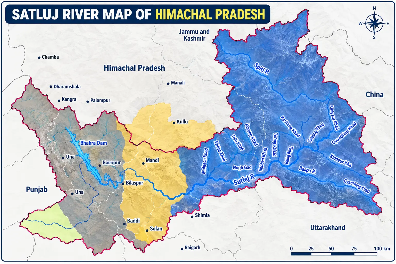
Use the map to locate the Satluj corridor, major river systems and important geographical areas of Himachal Pradesh.
Districts & Important Places Along the Satluj
The Satluj corridor is important for HP GK because it connects major river-course locations, settlements and hydropower centres. The section below separates the geographical corridor from the individual places so the information is easier to revise.
Upper Satluj Corridor
Important places associated with the upper Satluj include Shipki La, Namgia, Kalpa and Karcham.
Central Satluj Corridor
Important settlements along this corridor include Rampur, Suni and Tattapani.
Lower Satluj & Bhakra
The lower Satluj reaches Bhakra, where the Bhakra Dam and Gobind Sagar are major landmarks.
Tributaries of Satluj River
Spiti River
Originates in the Kunzum Range in Lahaul and Spiti. It drains the Pin and Spiti valleys and joins the Satluj at Namgia in Kinnaur.
Baspa River
The Baspa originates in the Baspa Hills and joins the Satluj in the Kinnaur section near Karcham. Snowmelt contributes substantially to its flow.
Soan River
The supplied study material describes the Soan as originating from the southern slopes of the Shivalik Range and flowing along the Himachal–Punjab boundary, with lower summer flow and monsoon flooding.
Major Hydropower Projects on the Satluj River System
The Satluj basin is one of Himachal Pradesh’s most important hydropower corridors. The following projects are useful for exam preparation and should be learned together with their river/location.
| Project | Capacity | River / Basin | Key association |
|---|---|---|---|
| Nathpa Jhakri HPS | 1,500 MW | Satluj | Nathpa–Jhakri corridor |
| Karcham Wangtoo | 1,091 MW | Satluj | Kinnaur |
| Rampur HPS | 412 MW | Satluj | Rampur |
| Baspa II | 300 MW | Baspa | Satluj river system |
| Koldam | 800 MW | Satluj | Bilaspur region |
Bhakra Dam & Gobind Sagar
The Bhakra Dam is a major structure associated with the Satluj. It is located at Bhakra in Bilaspur district, while Gobind Sagar is the reservoir formed behind the dam.
Important Satluj River Facts
Quick revision points covering the facts most useful for understanding and revising the Satluj River in Himachal Pradesh.
Satluj enters Himachal Pradesh through Shipki La in Kinnaur.
The Satluj flows for about 320 km within Himachal Pradesh.
Its Vedic/Sanskrit name is given as Satadru / Shatadru.
In Tibet, the river is known as Langqen Zangbo.
The Spiti River joins the Satluj at Namgia.
The Baspa River joins the Satluj in the Kinnaur section near Karcham.
Bhakra Dam and Gobind Sagar are major Satluj landmarks in the Bilaspur region.
Tattapani is an important settlement associated with the Satluj valley and its hot springs.
After entering Punjab, the Satluj meets the Beas at Harike.
The Satluj forms part of the broader Indus river system.
What to Remember for HP Exams
Use this final revision sheet after studying the detailed sections above.
Test Your Satluj River Knowledge
Practice topic-wise HP Geography MCQs with answers and explanations.
Practice Satluj River MCQs →Frequently Asked Questions
Where does the Satluj River originate?
The Satluj originates in Tibet in the Rakshastal / Mansarovar region, near the southern slopes of Mount Kailash.
Where does the Satluj enter Himachal Pradesh?
The Satluj enters Himachal Pradesh through Shipki La in Kinnaur, at a high-altitude Himalayan corridor.
Which are the important tributaries of the Satluj in Himachal Pradesh?
The major tributaries highlighted on this page are the Spiti River and Baspa River. Spiti joins at Namgia, while Baspa joins in the Kinnaur section near Karcham.
Which major hydropower projects are associated with the Satluj river system?
Important projects include Nathpa Jhakri HPS, Karcham Wangtoo, Rampur HPS and Koldam. Baspa II is also associated with the Satluj river system through the Baspa basin.
What are Bhakra Dam and Gobind Sagar associated with?
Bhakra Dam is a major structure on the Satluj, and Gobind Sagar is the reservoir formed behind the dam.