
Himachal Pradesh Physiography
Study the geographical location, physiographic divisions, mountain ranges, important peaks, passes and valleys of Himachal Pradesh in an exam-focused format.
Explore the Physiography of Himachal Pradesh
The state of Himachal Pradesh that lies in North India is compact in shape and almost wholly mountainous. Mighty Himalayan ranges, lofty peaks, beautiful valleys and natural passes in between the mountains make the physiographic profile of the state.
Himachal Pradesh is situated in the North-West corner of India in Western Himalayas. It is spread over an area of 55673 sq km. It is a landlocked state that is surrounded by China in the East and four Indian states on other sides.
Geographical Location of Himachal Pradesh
Geographical Extent
The geographical location of Himachal Pradesh is 30°2’40” to 33°12’40” North latitude and its longitudinal extent is 75°45’55” East to 79°04’20” East.
Neighbouring States and Regions
It is bordered by Jammu and Kashmir in the North, Punjab in the South-West, Haryana in the South, Uttarakhand and Uttar Pradesh in the South-East and China in the East.
Altitude
The average altitude of the region ranges from 350 m in plains of Kangra and Una to nearly 6975 m in Central Himalayan range of Lahaul and Spiti. The elevation of the state increases from West to East and from South to North.
Administrative Facts
Shimla is the first capital and Dharamshala is the second winter capital of Himachal Pradesh as declared on 19th January, 2017. For administrative purpose, the state is divided into 12 districts.
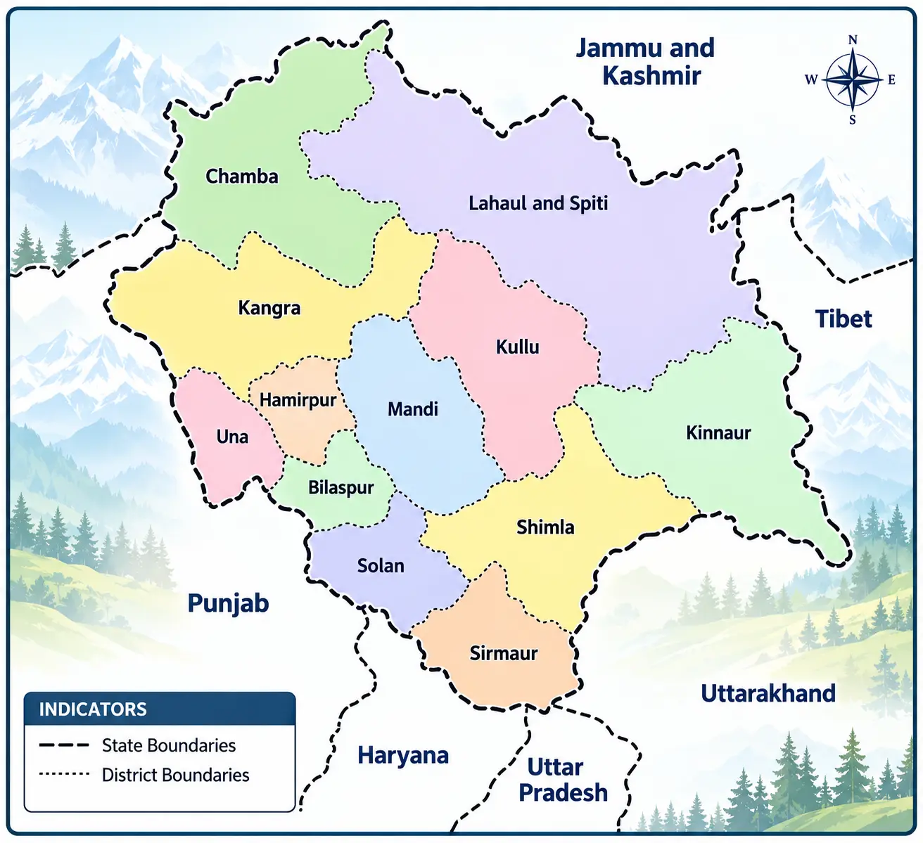
Districts Sharing Boundaries
| Neighbouring State / Region | Districts / Boundary Details |
|---|---|
| Uttarakhand | Kinnaur, Shimla, Sirmaur |
| Uttar Pradesh | Sirmaur with Yamuna river in the middle |
| Punjab | Una, Bilaspur, Solan, Sirmaur |
| Jammu & Kashmir | Kangra, Chamba, Lahaul and Spiti |
| Tibet | Kinnaur, Lahaul and Spiti |
Physiographic Divisions of Himachal Pradesh
The mountain ranges in Himachal Pradesh are divided into four physiographic divisions from South to North, with increasing height:
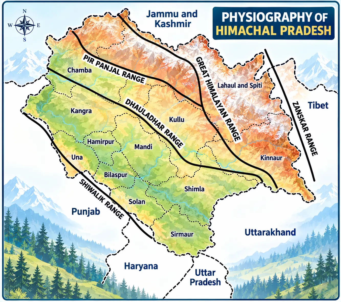
The Lower Hills or Outer Himalayas (Shivalik)
The altitude of this zone ranges from 300 m to 1500 m above the mean sea level. The outer Himalayas is also known as Shivalik hills and Mainak Parbat during ancient times. The word Shivalik literally means tresses of the Shiva or hairlock of Lord Shiva. Shivalik range is the youngest of Himalayan family.
The hills of this region contain loose rocks and soils which are prone to erosion and deforestation, which results in the formation of chos or gullies which are common in Una district. Large portion of Shivalik are at places separated by flat bottomed valley covered with rainfed streams, thick gravel and alluvium. These are called Duns.
Important Shivalik Facts
- Churdhar or Choor Chandni (3647 m) in Sirmaur is the highest peak of Shivalik range.
- This mountain range separates Sirmaur from Shimla.
- It covers the lower hills of Kangra, Hamirpur, Una, Bilaspur and lower parts of Mandi, Solan and Sirmaur.
- Local names include Ram Garh Dhar in Una, Dhog Dhar in Sirmaur, Dharti Dhar, Chamukti Dhar, Sikander Dhar and Naina Devi Dhar in Bilaspur.
The Lesser or Inner Himalayas (Central Zone)
The lesser or inner Himalaya range occupies the central part of Himachal Pradesh. The altitude of this zone shows a mean elevation of 1500 to 4500 m. This zone comprises the area of Pachhad tehsil (upper areas) Sirmaur, the upper areas of Kangra, Karsog and Chachyot tehsils of Mandi, upper hills of Shimla and upper parts of Churah tehsil of Chamba.
This zone consists of two ranges: Dhauladhar and Pir Panjal.
Dhauladhar Range
Dhauladhar range is the outermost portion of the inner Himalayas. The mean elevation of this range is 4550 m. It is also known as ‘White Range’. This range starts from Badrinath (in Uttarakhand) and it is intercepted by the river Sutlej (at Rampur-Bushahr), river Beas (at Larji) and river Ravi (at the South-West of Chamba).
Kangra, Chamba, Kullu and Manali districts lie in this range. The highest peak of this range is Hanuman Ji Ka Tibba or White Mountain which is 5639 m high. In Mandi district, its peak is Nagru (4020 m).
The Northern part of Dhauladhar range collide against the Southern part of Pir Panjal range at the mountain knot of Bara Bangal.
Pir Panjal Range
The Pir Panjal range at an average height of 5000 m, is a group of mountains in the inner Himalayan region, running from East-South East to West-North West across Himachal Pradesh and Jammu and Kashmir. It is the largest range of the lower Himalayas which mostly contains volcanic rocks.
The major expansion of Pir Panjal range is found in Chamba district. It forms a water divide between the river Chenab on one side and Beas and Ravi on the other. It separates Kullu valley from Lahaul valley. The famous Rohtang Pass lies in this range.
The Great Himalayas or Alpine Zone or Himadri
This is the highest mountain range zone with an altitude from 5,000 m to 7,000 m. The Great Himalayan range runs along the Eastern boundary of Himachal Pradesh. This zone is separated by the river Sutlej in two parts, the same river also separates Pir Panjal range from this range.
This range separates the drainage of river Spiti from the Beas. The entire range gets heavy snowfall which act as water source for many snowfed rivers. This area comprises of Kinnaur district, Pangi tehsil of Chamba district and some areas of Lahaul and Spiti. This range obstructs the path of South-West monsoons winds from moving any further.
Zanskar Range (Shilla Peak-Kinnaur)
It is the Easternmost range and it separates Kinnaur and Spiti from Tibet, Kashmir and Ladakh. The average elevation of this range is 3000 m. Shilla peak (7026m), the highest peak of Himachal Pradesh, lies in this range.
Sutlej river passes from this range and forms deep gorges. Parts of Kinnaur and Lahaul and Spiti lie in this range. The Zanskar range is cut across by the river Sutlej through degraded material of Shipki La pass.
Important Mountain Peaks of Himachal Pradesh
| Location | Name of the Peak |
|---|---|
| Kinnaur | Shilla (Highest peak in Himachal Pradesh), Reo Purgyl, Kinnaur Kailash, Shipki-La |
| Lahaul and Spiti | Manerang (Highest peak in Lahaul and Spiti district), Mulkila, Gyephang, Sangri La, Lady of Keylong |
| Kullu | Deo Tibba, Hanuman Ji ka Tibba (White Mountain), Pin Parbati, Indrasen |
| Kangra | Cholang |
| Chamba | Pir Panjal Highest peak in Chamba, Manimahesh Kailash (in Bharmour) |
| Shimla | Chanshal |
| Sirmaur | Churdhar/Choor Chandni (Highest peak in Shivalik range) |
Passes in Himachal Pradesh
Passes are the natural navigable route through a mountain range. Some of the famous passes of Himachal Pradesh are given below.
Pin Parbati Pass
It is famous as Valley of Shadows. This pass is situated at an altitude of 5,319 m above sea level. It is located in the Kullu-Spiti region. This pass is distinguishable for its rocky terrains. It connects Parbati valley of Kullu with Pin valley of Lahaul and Spiti district.
Baralacha La Pass
Baralacha La literally means summit with cross roads. It is situated at an altitude of 4,890 m. It is a high mountain pass in Zanskar range, connecting Lahaul in Himachal Pradesh to Ladakh in Jammu and Kashmir, situated along the Leh-Manali highway. Here roads from Spiti, Ladakh, Zanskar and Lahaul meet and in ancient times, it was part of a trade route.
Kunzum Pass
It is famous as on the footprints of Rohtang. This pass is the gateway to Lahaul. It is located at the height of 4557 m above sea level. It is a high mountain pass on the Eastern Kunzum range of the Himalayas. It connects Kullu and Lahaul valley with the Spiti valley of Himachal Pradesh. This pass remains open all the year round due to favourable climatic conditions.
Shipki La Pass
It is located in Kinnaur-Tibet at an elevation of 4500 m. It connects Himachal Pradesh with Tibet. The river Sutlej enters India (from Tibet) through this pass. It is an offshoot of the ancient silk road.
Rohtang Pass
It is the most famous pass in the state as well as in the country. This pass connects Kullu valley with Lahaul and Spiti valley and is located at the height of 3,978 m above sea level in Kullu district. This pass is open only from the month of June to September, where the population is predominantly Buddhists. Rohtang Pass has better connectivity by roads from Manali-Kullu valley.
Important Passes of Himachal Pradesh
| Name | Connects |
|---|---|
| Kangla | Spiti-Ladakh |
| Debsa and Borsa | Spiti-Kullu |
| Pin Parbati | Spiti-Kullu |
| Kugti | Lahaul-Bharmour (Chamba) |
| Yangzi Diwan | Lahaul-Spiti |
| Rupin | Kinnaur-Garhwal |
| Indrahar | Kangra-Bharmour (Chamba) |
| Jalsu and Waru | Kangra-Chamba |
| Saach | Chamba-Pangi |
| Dulchi | Mandi-Kullu |
| Jalori | Outer-Inner Seraj (Kullu) |
Valleys of Himachal Pradesh
The landscape of Himachal Pradesh is dotted with many magnificent valleys where many important cities and towns are established. Some of the important valleys of the state are given below.
Kullu Valley
It is situated at the height of 1279 m. The Beas river runs through the middle of the valley. It is also called the Valley of the Gods. It connects with the Lahaul and Spiti valleys via Rohtang pass. The valley extends 80 km North from Larji Gorge, near Mandi and ends near the famous Rohtang Pass. The valley is covered with pine deodar forests and wild flowers.
The main town of this valley is Kullu which is situated at a height of 1,200 metres. Manali an altitude of 1926 metres is a famous tourist destination of this valley. The Kullu valley is famous for apple orchards, hot water springs (e.g. Manikaran, Nehru Kund), Hidimba temple, Kullu Dussehra, handwoven shawls and Kullu caps.
Kangra Valley
It is situated in Kangra district. It is also known as Veer Bhoomi of Himachal Pradesh. Its average elevation is 610 m. The valley has numerous perennial streams along with Beas river that irrigates the valley. The slope of the valley rises from West to East rising gradually from Shahpur to Baijnath and Palampur.
The Kangra valley is also important from historical point of view as Palaeolithic hand tools were found in this area. The important towns of this valley are Baijnath, Palampur, Kangra and Dharamshala (district capital). The valley is best known for its beauty, ancient temples, Kangra fort, Kangra paintings and a home to Gaddi shepherds.
Lahaul and Spiti Valleys
Lahaul and Spiti are two valleys of Himachal Pradesh that lie on the Indo-Tibet border. These valleys are surrounded by mountains with elevations from 3000 to 6500 m above the mean sea level.
Lahaul Valley: It lies to the North of the Pir Panjal range in between Chandra and Bhaga rivers that meet at Tandi to form Chenab river. Big Shigai and Nohtang mountains are located here. Lahaul has a mix of Hindu and Buddhist population and the entire valley gets heavy snowfall.
Spiti Valley: The name Spiti means the Middle Land, i.e. the land between Tibet and India. It literally means Land of Jewels. It lies in the North-East corner of the state and is bounded by Ladakh, Tibet and Kinnaur on other three sides. It is situated along the Spiti river at an elevation of about 4,000 m above mean sea level. The Spiti valley is a cold desert mountain valley.
Chamba or Ravi Valley
This valley lies between the Zanskar and Dhauladhar range in the South of the Himalayas. This U-shaped valley is situated at the height of 996 m on the South bank of the river Ravi. According to historians, Chamba was founded by Raja Sahil Verma in AD 920 who named it after his daughter Champavati.
In the lower parts of the valley, wild olive, pomegranate and fig trees grow along with semi tropical trees like pipal, shisham, acacia. The valley is densely populated as it provides gentle slopes where cultivation is possible.
This valley is famous for medicinal herbs and varieties of flowers. The famous Monkey valley (Bandar Ghati) lies in Chamba. The important towns located in this valley are Dalhousie, Khajjiar, Chamba and Bharmour. Chamba is the district headquarters in this valley. The people who live in this valley are called Chambial.
Paonta or Kiarda Dun Valley
It lies in Sirmaur district between the Eastern edge of Markanda and the Dharti ranges. It slopes towards South-Eastern corner of the state. River Yamuna separates it from Dehradun. A Sikh Gurudwara at Paonta Sahib and a Ram Mandir are the two famous religious places in this valley.
This valley is divided into three parts or regions:
- The first region is Dun Giri and Bata river flow here.
- The second region consists the Neli Khera and the adjoining hills of the lower Dharti ranges.
- The third region is Par Dun which is located north of Majra village across the Bata stream. The valleys are heavily cultivated and support large number of population.
Some Other Valleys of Himachal Pradesh
| Valley | Description |
|---|---|
| Sangla/Baspa Valley | It lies in Kinnaur and ranges from 1830 m to 3475 m (in Chitkul). It is the largest and most beautiful valley in Kinnaur. |
| Mulgun and Rupin | It is located at Kinnaur district. |
| Hangrang Valley | This valley is located near the Indo-Tibetan border in the Kinnaur district. |
| Pattan Valley | It is located at Lahaul and Spiti district. |
| Pin Valley | It is situated in Lahaul and Spiti and ranges from 3500 to 6000 m. It is also declared as National Park in 1987. |
| Pangi Valley | It ranges from 2100 to 3400 m and lies along the banks of Chenab river. Gyas peak lies here. |
| Solang Valley | It lies in Kullu district and is famous for winter skiing festival and paragliding in Himachal Pradesh. |
| Balh Valley | It is situated in Mandi district between Shimla ridge and Shivalik hills. The valley’s altitude is about 800 m above mean sea level. |
| Demi Valley | It is situated between Bahadurpur and Bandla ranges at an elevation of 800 m. |
| Pabbar or Rohru Valley | It begins at Hat-Koti, and extends upto Tikri at the base of Chanshal range. Blue, Pine, Spruce, Silver fir trees grow here. |
| Kunihar Valley | It is situated in Solan district at a height of 1000 m. It is also known as Hat Kot and Choti Vilayat. |
Physiography Revision Points
- Himachal Pradesh is almost wholly mountainous and lies in the Western Himalayas.
- The state is divided into four physiographic divisions from South to North.
- The four divisions are Shivalik, Lesser/Inner Himalayas, Great Himalayas/Himadri and Zanskar/Trans-Himalayas.
- Churdhar/Choor Chandni is listed as the highest peak of the Shivalik range in the source material.
- Dhauladhar and Pir Panjal are the two ranges listed under the Lesser or Inner Himalayas.
- Rohtang Pass separates/connects the Kullu and Lahaul-Spiti valley system in the source material.
- Shilla Peak is identified in the source as the highest peak of Himachal Pradesh.
- Kullu, Kangra, Lahaul-Spiti, Chamba/Ravi and Paonta/Kiarda Dun are among the major valleys covered here.
Practise Himachal Pradesh Geography MCQs
After studying physiography, reinforce your preparation with topic-wise MCQs covering location, mountain ranges, peaks, passes and valleys.