
Do you know?
- How many mountain ranges are there in Himachal Pradesh?
- What is the elevation of Himachal Pradesh?
- Which is the highest peak of Himchal Pradesh? What is its height and name the district where it is located?
These are very common question asked in HP GK portion of any HP Govt exam conducted by HPPSC or HPRCA. We know the value even one mark in this era of cutting edge competition. We also know the hard work and patience the students are pouring in the preparation of HP Govt exam. So we at HPJobBuzz designed multiple choice questions (MCQs) to boost your confidence and help you in preparation.
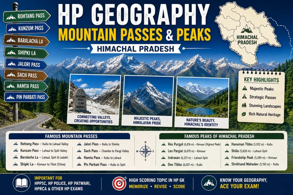
The Geography, Mountain Passes, and Peaks of Himachal Pradesh form one of the most important sections of Himachal Pradesh General Knowledge (HP GK). Located in the Western Himalayas, Himachal Pradesh covers an area of 55,673 square kilometres and is characterized by rugged mountain ranges, high-altitude passes, snow-clad peaks, deep valleys, glaciers, and river systems. The state’s elevation ranges from about 350 metres above sea level in the Shivalik foothills to over 6,800 metres in the Greater Himalayas, making it one of India’s most geographically diverse states.
Mountain passes have historically served as vital trade and pilgrimage routes connecting Himachal Pradesh with Ladakh, Tibet (China), Uttarakhand, Jammu & Kashmir, and the plains of Punjab. Famous passes such as Rohtang Pass, Kunzum Pass, Baralacha La, Shipki La, Jalori Pass, Sach Pass, Hamta Pass, Chanshal Pass, Indrahar Pass, and Pin Parbati Pass are important from both geographical and strategic perspectives. Several of these passes remain snowbound during winter and reopen only during the summer months.
Himachal Pradesh is also home to some of the highest peaks in the Indian Himalayas. Reo Purgyil (6,816 m), located in the Kinnaur district, is the highest peak in Himachal Pradesh and lies near the Indo-Tibetan border. Other significant peaks include Leo Pargial, Indrasan, Deo Tibba, Hanuman Tibba, Shilla, Friendship Peak, Kinner Kailash, Manimahesh Kailash, and Shrikhand Mahadev. These peaks are renowned for mountaineering, religious significance, glaciers, and breathtaking landscapes.
The mountain ranges of Himachal Pradesh include the Shivalik Range, Dhauladhar Range, Pir Panjal Range, Zanskar Range, and the Great Himalayan Range. Together, these ranges influence the state’s climate, river systems, biodiversity, agriculture, and tourism, making them essential topics for competitive examinations.
This practice set contains exam-oriented MCQs covering the major mountain passes, peaks, mountain ranges, elevations, districts, strategic importance, glaciers, and geographical facts of Himachal Pradesh. Every question includes the correct answer, detailed explanation, and an additional exam fact, making it an excellent resource for quick revision and competitive examination preparation.
Importance of Geography, Mountain Passes & Peaks for HP Government Exams
The Geography, Mountain Passes, and Peaks of Himachal Pradesh constitute one of the most frequently tested topics in HP Geography and Environment. Questions from this section are regularly asked in HPPSC, HP Police, HP Patwari, HPRCA, JOA, Naib Tehsildar, Forest Guard, TGT, and other Himachal Pradesh Government recruitment examinations.
Examiners commonly ask questions on:
- 🏔️ Highest peaks and their districts
- ⛰️ Major mountain passes and the regions they connect
- 🗺️ Mountain ranges and their locations
- 📍 Important glaciers and river origins
- 🚗 Passes connecting valleys and neighbouring states
- ❄️ Snowbound and strategic mountain passes
- 🛕 Peaks with religious significance
- 🌄 Altitudes and elevation-based questions
- 🌿 Great Himalayan National Park and associated ranges
- 🏞️ Trekking routes and famous Himalayan landscapes
Some of the most frequently asked exam facts include:
- 🏔️ Reo Purgyil (6,816 m) is the highest peak in Himachal Pradesh.
- 🚪 Shipki La is the principal mountain pass connecting Himachal Pradesh with Tibet (China).
- 🚗 Rohtang Pass connects the Kullu Valley with Lahaul Valley.
- ❄️ Kunzum Pass links Lahaul with Spiti Valley.
- 🏔️ Baralacha La is the meeting point of routes leading to Ladakh, Lahaul, and Spiti.
- 🌊 The Beas River originates near Rohtang Pass at Beas Kund.
- 🛕 Kinner Kailash and Shrikhand Mahadev are among the most sacred mountain peaks in Himachal Pradesh.
Since most questions from this topic are direct, map-based, and fact-oriented, it is regarded as one of the highest-scoring areas in HP GK. Candidates who remember the pass, connecting regions, district, mountain range, and unique feature can answer a significant number of geography questions with confidence.
Exam Tip:
Revise each location using this sequence:
Peak/Pass → District → Mountain Range → Elevation/Connection → Important Exam Fact
This revision method covers the majority of questions asked in HP Government examinations.
Test Your Knowledge
Are you ready to test your preparation? Dive into the 15 highly anticipated multiple-choice questions below and see how many you can get right!
Key Facts Recap
HP Economy, Hydro Projects & Agriculture – HP Daily GK MCQs
Geographical Rivers & Glaciers of Himachal Pradesh -HP Daily GK MCQs
📲 Get Daily HP GK Updates
Join our WhatsApp channel for daily HP GK MCQs, HPRCA job alerts & exam updates
Join WhatsApp ChannelRelated Pages:
➡️ Rivers of Himachal Pradesh – Complete Guide